Pilot was great and provided excellent video and aerial photography for the property.
Charles Mazzini
Acquisition Manager
Trustland Group LLC
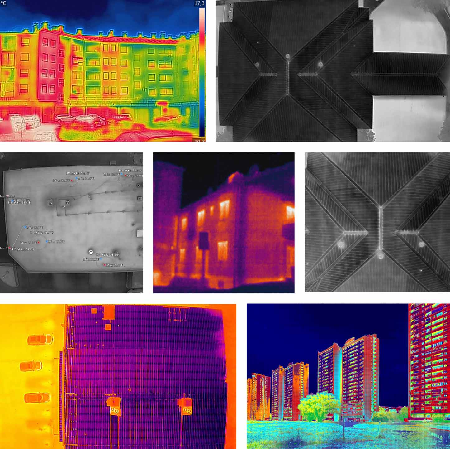
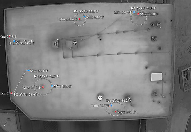
Drone thermal imaging provides a fast and efficient way to detect hidden structural issues that may not visible during standard inspections. Precision 3D DFW offers professional drone thermal imaging services for residential, commercial, industrial, and roofing inspections throughout the Dallas–Fort Worth area using advanced infrared drone technology. Our drone thermal
images help identify roof leaks, trapped moisture, insulation problems, electrical hotspots, and heat loss before they become expensive repairs. Unlike traditional inspections, thermal drone technology allows large rooftops and hard-to-reach areas to be inspected safely without ladders or major disruption to the property. Drone thermal imaging services are commonly used for preventative maintenance, roofing evaluations, solar
inspections, and commercial property assessments because they provide fast, accurate, and non-invasive results. Precision 3D DFW combines FAA-certified drone operations with professional thermal imaging equipment to deliver reliable aerial thermal inspections for property owners and businesses across Texas.
Why Property Owners Choose Our Thermal Imaging Services
Improve safety, reduce access risks, get updates on timelines and benchmarks and capture detailed visual data for rooftops, towers, equipment, structures, and other hard-to-reach areas.

Create more engaging content that captures attention, strengthen branding, and helps properties and businesses stand out in competitive markets.

Gain better property and site insights, improve planning accuracy, and document land and project conditions with detailed aerial perspectives and spatial data collection.
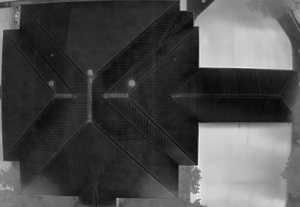
Our drone thermal imaging services include aerial infrared inspections, high-resolution drone thermal images, thermal footage capture, and professionally organized deliverables for residential and commercial properties. Every inspection begins with a review of the property and inspection goals to determine the most effective flight paths and thermal scanning areas. Using advanced infrared drone technology, we capture thermal imagery designed to document roof conditions, moisture intrusion, insulation concerns, electrical hotspots, and other temperature-related anomalies. The collected thermal images and footage provide property owners, contractors, inspectors, and facility managers with valuable aerial thermal visuals for further evaluation. We deliver organized thermal files that can be used for preventative maintenance planning, roofing inspections, property assessments, and project documentation. Our goal is to provide reliable drone thermal imaging services that help clients safely and efficiently capture accurate thermal visuals from above.
Our drone thermal imaging process is designed to provide fast, safe, and efficient inspections without disrupting the property. Before the inspection begins, we evaluate the structure, environmental conditions, and inspection objectives to determine the best time and flight conditions for accurate thermal image capture. During the inspection, FAA-certified drone pilots use specialized infrared cameras to capture detailed thermal images across rooftops, building exteriors, electrical systems, solar panels, and other structures. The drone allows large or difficult-to-access areas to be documented quickly without requiring ladders, scaffolding, or manual roof access. Once the flight is completed, the captured thermal images and footage are organized and prepared for client delivery. This process allows property owners and contractors to obtain aerial thermal visuals efficiently while minimizing safety risks and property disruption.
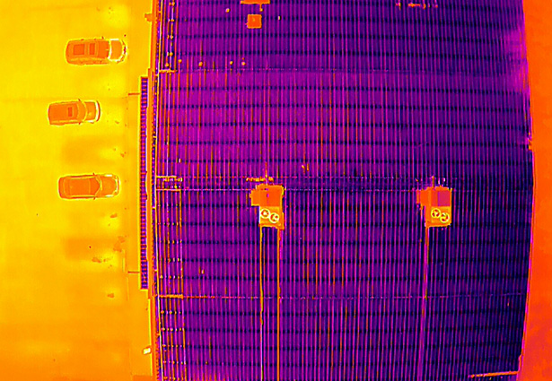
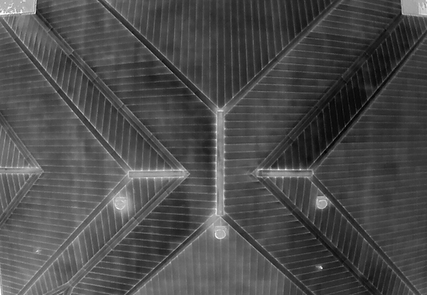
Professional drone thermal imaging requires more than a standard drone camera, which is why we use advanced infrared imaging technology designed specifically for thermal inspections and temperature visualization. Our thermal drones capture high-resolution drone thermal images that help document heat signatures, moisture intrusion areas, roof conditions, insulation gaps, and electrical hotspots across residential and commercial properties. The quality of thermal imaging equipment plays a major role in producing clear and consistent infrared visuals during an inspection. We use professional-grade thermal sensors capable of capturing detailed thermal imagery while maintaining stable aerial positioning for accurate image collection. This allows us to safely document large rooftops, commercial facilities, industrial equipment, and hard-to-reach structures more efficiently than many traditional inspection methods. Using professional thermal drone equipment helps ensure clients receive reliable aerial thermal visuals for their inspection and documentation needs.
Drone thermal imaging services are commonly used for residential homes, commercial buildings, industrial facilities, warehouses, apartment complexes, office buildings, and roofing systems. Large rooftops and difficult-to-access structures benefit especially well from aerial thermal inspections because drones can safely capture detailed thermal images without requiring ladders, scaffolding, or manual roof access. Thermal imaging is also frequently used for solar panel inspections, moisture documentation, electrical system evaluations, insulation assessments, and preventative maintenance projects. Commercial property owners often use drone thermal imaging to document building conditions and support maintenance planning across large facilities. Residential homeowners may use thermal drone inspections after storms, roofing projects, or property evaluations to capture aerial infrared visuals of the structure. Every property type benefits from the speed, safety, and efficiency that professional drone thermal imaging services provide.
Fast turnaround times are important when property owners, contractors, and inspectors need thermal imagery for active projects or evaluations. Our drone thermal imaging services are designed to provide efficient scheduling, streamlined inspections, and organized file delivery so clients can receive their thermal images as quickly as possible. After the drone flight is completed, all infrared footage and drone thermal images are organized and prepared for digital delivery. Most residential thermal imaging projects can be delivered within a few days depending on the size of the property and the amount of footage captured during the inspection. Larger commercial or industrial projects may require additional processing time due to the scale of the property and volume of thermal imagery collected. We focus on providing fast and reliable drone thermal imaging services that help clients move forward with their inspections, reports, and property evaluations efficiently.
After the drone thermal imaging flight is completed, all captured thermal images and infrared footage are organized and delivered to the client in high-resolution digital formats. The footage and drone thermal images can then be reviewed by roofing professionals, contractors, inspectors, engineers, insurance adjusters, or other qualified specialists depending on the purpose of the inspection. Our role is to safely capture accurate aerial thermal imagery using professional infrared drone equipment while providing clear and organized visual documentation of the property. We focus on delivering clean, high-quality thermal drone footage that helps support inspections, maintenance planning, property evaluations, and repair assessments. Files are prepared for easy viewing and sharing across reports, presentations, maintenance records, and project documentation. Precision 3D DFW provides professional drone thermal imaging services designed to give clients reliable aerial thermal visuals for their specific inspection or evaluation needs.
Pilot was great and provided excellent video and aerial photography for the property.
Charles Mazzini
Acquisition Manager
Trustland Group LLC
Pilot was great, very detailed and provide exactly the right images, he confirmed everything in advance and delivered everything very quickly in multiple high quality formats, will use again for sure!
Matt Scow
Executive Vice President
SecureNetLease.com
An absolute pleasure to work with! Delivers high quality results and has great attention to detail. We’ll definitely be working with him on many projects to come!
Benjamin Martinez
Chief Pilot
Vimana Aerial Solutions